


|
|
|
|
JT1
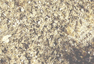
Joshua Tree National Park, Pinto Basin, Riverside County, California, USA. 33° 52.945' N latitude, 115° 43.930' W longitude. Four miles down Old Dale Road, east side of road. Date of sampling: 8 June 1998. Dominants vascular plants at the site: Cheesebush, Chorizanthae (disarticulating type), Larrea tridentata Other plants: Eriogonum sp. (delicate), Opuntia bigelovii, Opuntia ramosissima, Sarcostemma cyanchoides ssp. hartwegii, Schismus sp., Desert monkeyflower (magenta flower), Smoke tree (spotted pods, spiny blue-green thing) Mean algal crust thickness (all 10 samples): 4.1 mm Cover summary (Preferentially sampled high algal crust areas, counts not representative of the whole area.): Type Cover % Cover Shrubs 0.0 Annuals 9.6 Perennial grasses 0.0 Perennial forbs 0.0 Algal crust 60.0 Bryophytes 0.0 Lichens 0.0 Bare Soil 20.0 Rock 0.8 Gravel 9.6 Litter 0.0 Cactus 0.0 Chlorophyll a (ng/g): 4860.26 N fixation rate (mmole/n2/m2/hr): 3649.16 Soil texture class: sandy loam
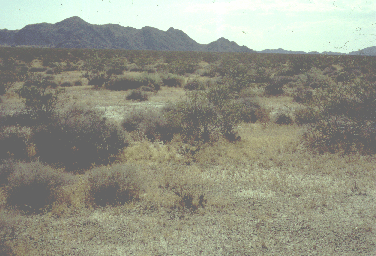
Joshua Tree National Park, Cadiz Valley, San Bernardino Co., California, USA. 34° 06.592' N latitude, 115° 28.821' W longitude. Area where restoration efforts are underway, south of Highway 62, east of Clark Pass. There is a large pull out, with the dirt road heading out of the pull out closed by the National Park Service. The study area was about 400 meters south of the pull out in a large flat area which may pond during heavy rains. Surface is covered with coarse sand and gravel which is subtended by a finer soil. Date of sampling: 8 June 1998. Dominants vascular plants at the site: Larrea tridentata, Ambrosia dumosa, Schismus barbatus Other plants: Chorizanthae rigida, Encelia sp. (frutescens or actoni), Petalonyx thurberi, Polygonum ovatum Mean algal crust thickness: 6.2 mm Cover summary: Type Cover % Cover Shrubs 0.0 Annuals 12.0 Perennial grasses 0.0 Perennial forbs 0.0 Algal crust 69.2 Bryophytes 0.0 Lichens 12.0 Bare Soil 2.0 Rock 0.0 Gravel 4.4 Litter 0.4 Cactus 0.0 Chlorophyll a (ng/g): 4165.94 N fixation rate (mmole/n2/m2/hr): 8647.22 Soil texture class: loamy sand
Joshua Tree National Park, Joshua Tree Forest, San Bernardino County, California, USA. 34° 02.545' N latitude, 116° 10.952' W longitude. Date of sampling: 9 June 1998. |